
By 1867, when the first edition of the Ordnance Survey map for Perthshire was published, many of the old homesteads in the parish of Blair Atholl were in ruins, deserted and forgotten. To discover the names of these homesteads, one must go back to James Stobie's 1783 map of Perthshire.
To view James Scobie's original map, which is in four sections, use the following hyper-link to the National Library for Scotland.
In the following lists the homesteads are arranged in the same order that they would be seen by a traveller following the road, or river. This is intended to assist in locating specific homesteads on the available maps. Some parts of the adjacent parishes are included, for example Glen Fincastle, which is part of Dull parish.
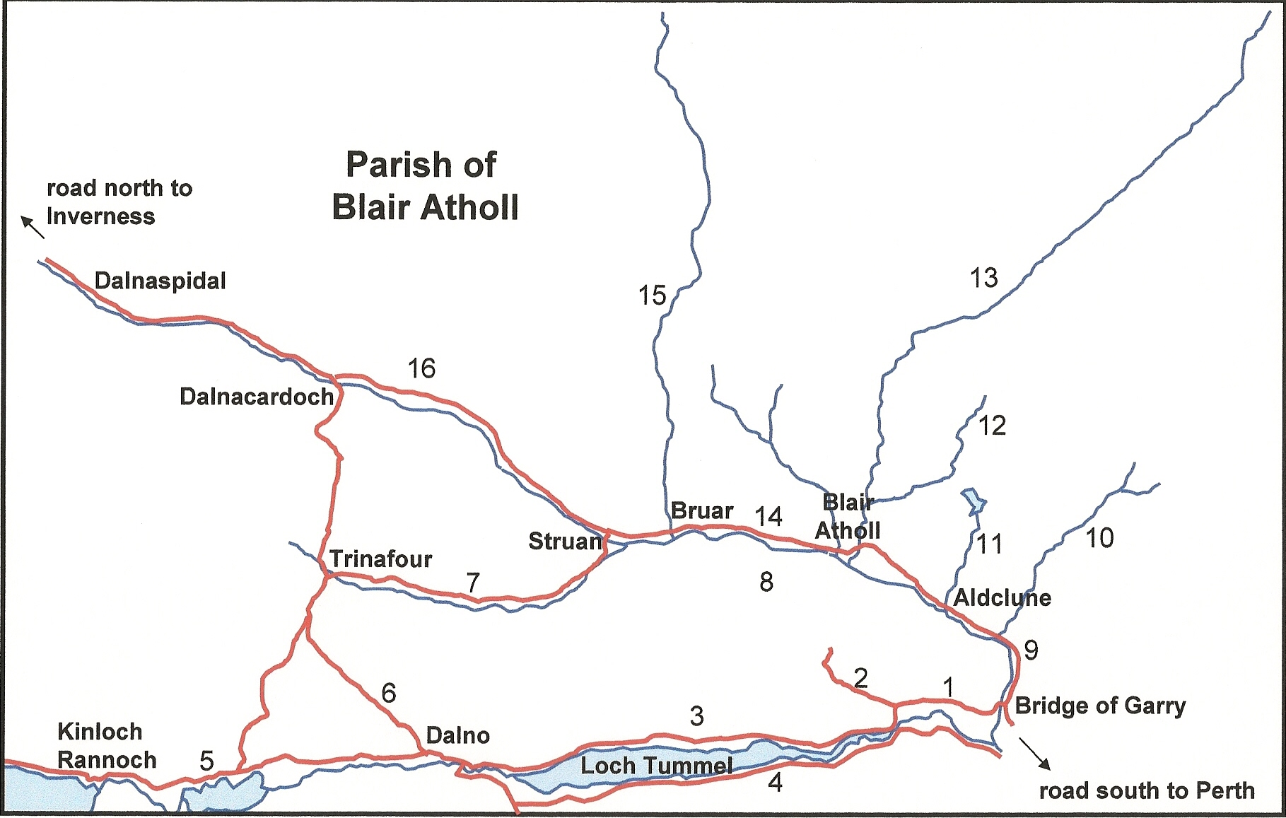
1. River Tummel from Bridge of Garry to Glen Fincastle
2. Glen Fincastle and the old Tummel road
3. Strathtummel and Borenich from Glen Fincastle to Dalno
4. South side of the Tummel from the Falls of Tummel to Tummel Bridge
5. Road to the Isles from Dalno to Kinloch Rannoch
6. The Wade Road from Dalno to Trinafour
7. Glen Errochty from Trinafour to Struan
8. South side of River Garry from Struan to Bridge of Garry
9. The North Road from Bridge of Garry to Blair Atholl
10. Glen Girnaig from the North Road
11. Allt Cluain from Aldclune to Loch Moraig
12. Glen Fender from Old Bridge of Tilt
13. Glen Tilt from Blair Atholl
14. The North Road from Blair Atholl to Bruar
15. Glen Bruar from the North Road
16. The North Road from Bruar to Dalnaspidal
1. River Tummel from Bridge of Garry to Glen Fincastle (listed from east to west)
| Homestead in Stobie's map, 1783 |
Name in O. S. map 1st edition, 1867 |
Location |
|---|---|---|
| Bridge of Garry | ||
| not shown on map | Killyvrochan Cottage | north of road |
| Coilbrochan | Killyvrochan | south of road |
| not shown on map | Home Farm | north of road |
| not shown on map | Bonskeid House | south of road |
| Bonskeid | Mains of Bonskeid | north of road |
| not shown on map | Woodend | just past Glen Fincastle |
| Allean | Allean House | south of road |
| Balintuim | Ballintuim | north of road |
| Balinluig | Ballinluig | by the Queen's View |
| Tombue | un-named ruins | north of road |
| Ardghualich | Ardgualich | south of road |
| Larigchastle | un-named ruins | north of road |
2. Glen Fincastle and the old Tummel road (listed from south to north)
| Homestead in Stobie's map, 1783 |
Name in O. S. map 1st edition, 1867 |
Location |
|---|---|---|
| Milltown | Milton | two mills on river |
| unidentified | Ballinealich | east of river |
| Pilvealain | un-named ruins | below Clochkan |
| Clochkan | Clochkan | east of river |
| Balnavid | un-named ruins | east of river |
| Little Milltown | Little Milton | two mills on river |
| Dundavie | Dundavie | east of river |
| Chapeltown | Chapelton | west of road |
| Balinauld | Balnald | west of road |
| Edintiain | Edintian | west of Balinauld |
| Balno | not shown on map | east of road |
| Foncastle | Fincastle House | house east of road |
| Croft-roun | Croftgoul | beyond Fincastle House |
| Drumdaghoun | Drumnagowan | west of road |
| Park | not shown on map | west of road |
| Achastil | Achcastle | beyond Park |
| Fiermore | Fiermore | at end of road |
| Newtown | not shown on map | west of Fiermore |
| Carick | Carrick | west of Newtown |
| Tominrait | Tomanraid | east of Fiermore |
3. Strathtummel and Borenich from Glen Fincastle to Dalno (listed from east to west)
| Homestead in Stobie's map, 1783 |
Name in O. S. map 1st edition, 1867 |
Location |
|---|---|---|
| Tominbuy | Tom Buidhe | south of road |
| Laightown | un-named ruins | south of road |
| Croftcarnoch | not recorded on map | south of road |
| not shown on map | Borenich | south of road |
| Balinauld | not recorded on map | north of road |
| Ouchinenlach | un-named ruins | north of Balinauld |
| Balinloch | Balintochich | north of Ouchinenlach |
| unidentified | Knockgarry | west of Ouchinenlach |
| Balinchapel | Chapelton | south of road |
| Balastle | Bail a' Chaisteil | north of road |
| Croftdowglash | Croftdouglas | south of road |
| unidentified | Balnabruach | south of road |
| unidentified | Balnabodach | north of road |
| unidentified | Balnald | south of road |
| unidentified | Chamberbane | south of road |
| not shown on map | Lochtummel Inn | north of road |
| Balintuime | Balintuim | north of road |
| not shown on map | Bridgend | north of road |
| not shown on map | Woodend | north of road |
| Tressaid | Tressait | north of road |
| Tomintianda | Tomintianda | north of Tressait |
| Blarbuy | Blairbuie | north of Tomintianda |
| Portnellan | Portnellain House | south of road |
| Brookbane | Bruchbane | south of road |
| Grannich | Grennich | north of road |
| not shown on map | Portnellain Cottage | north of road |
| not shown on map | Aldcharmaig | south of road |
| Bohaly | Bohally | south of road |
| not shown on map | Wester Bohally | north of road |
| Dalchroy | Dalcroy | south of road |
| unidentified | Cuarteag | west of Tummel bridge |
| Dalino | Dalno | north of road |
4. South side of the Tummel from the Falls of Tummel to Tummel Bridge (listed from east to west)
| Homestead in Stobie's map, 1783 |
Name in O. S. map 1st edition, 1867 |
Location |
|---|---|---|
| Cammoch | Cammoch | south of road |
| castle in ruins | Torvuick | north of road |
| Ruichastil | Ruidh a' Chaisteil | south of road |
| Easter Duntaulich | Netherton | south of road |
| Middleton | Middleton | north of road |
| not shown on map | Runfad | south of road |
| Duntaulich | Duntanlich | south of road |
| Croftstockain | Croft Stochanan | south of road |
| Gartrenich | Ard Raineach | north of road |
| Druimachaildin | ruins | south of road |
| not shown on map | Loch Tummel Lodge | north of road |
| Lieck | Lick | south of road |
| Frenich | Frenich | north of road |
| not shown on map | Woodend Cottage | south of road |
| not shown on map | Ceann na Coille | south of road |
| Balmeanoch | not shown on map | south of road |
| Croftloan | not shown on map | south of road |
| Croftharrow | not shown on map | south of Croftloan |
| Foss | Foss House | south of road |
| Donacuil | Donacoul | south of road |
| Donagowan | west of Donacuil | |
| Donanlealain | Donlellan | both sides of road |
| not shown on map | Tynuilt | both sides of road |
| Mill | Millton | north of road |
| Kirktown | Kirkton of Foss | south of road |
| not shown on map | Donmaheich | south of road |
| Drumnacoile | Drumnakyle | south of road |
| Dow-crochen | not shown on map | south of Drumnacoile |
| Sococh | Socath-donn-nan-eun | south of Dow-crochen |
| Balinearn | Balnarn | both sides of road |
| Milltown | Daloist | south of road |
| Kynachan | Kynachan | east of road |
| not shown on map | Camp Haugh | south of road |
| Unidentified | Tummel Bridge Inn | south of road |
5. Road to the Isles from Dalno to Kinloch Rannoch (listed from east to west)
| Homestead in Stobie's map, 1783 |
Name in O. S. map 1st edition, 1867 |
Location |
|---|---|---|
| Thinford | not shown on map | south of road |
| Dalriach | Dalriach | north of road |
| not shown on map | Tomanbuidhe | north of road |
| not shown on map | Newton | north of road |
| Balintuime | Ballantuime | north of road |
| Achatarsan | Auchtarsin | north of Ballantuime |
| Mount Alexander | Dun Alastair | south of road |
| unidentified | Wester Ballantuime | north of road |
| not shown on map | Tigh na Bruaiche | south of road |
| unidentified | Balliemore | north of road |
| unidentified | Maragdubh | north of Balliemore |
| not shown on map | Tigh na Leth Mhairg | west of Maragdubh |
| Easter Drumachewan | Lochgarry Cottage | north of road |
| unidentified | Lochgarry House | south of road |
| not shown on map | Druim-glas | north of road |
| not shown on map | Tigh na Cuile | north of Druim-glas |
| Achlatt | Auchtibart | north of road |
| Drumachastle | Druimchastle | south of road |
| Wester Drumachewan | not shown on map | south of road |
| unidentified | Tom-clachach | north of road |
| Kinloch Rannoch | Kinloch Rannoch | town at bridge |
6. The Wade Road from Dalno to Trinafour (listed from south to north)
| Homestead in Stobie's map, 1783 |
Name in O. S. map 1st edition, 1867 |
Location |
|---|---|---|
| Dalino | Dalno | north of junction |
| Nether Bohespike | Easter Bohespic | east of road |
| unidentified | Teighnacoil | east of road |
| Gascan | Lower Gaskan | east of road |
| unidentified | Upper Gaskan | east of road |
| unidentified | Teighmore | east of road |
| Wester Bohespike | Over Bohespic | east of road |
| Glackvoidoch | un-named ruins | west, by river |
| Black-park | Blackpark | other side of river |
| Milnavady | Mullinavadie | single mill on river |
| Linemore | Loinn Mhor | west, by river |
| Linemeanoch | Loinn Mheadhonach | west, by river |
| Linehagoch | un-named ruin | west, by river |
| Riencluich | Ruidh Fluich | west of road |
| Drumachruie | Druim Cruaich | west of road |
| Croitnagie | Croit nan Gamhna | west of road |
| Trinyfour | Trinafour | bridge over Errochty |
7. Glen Errochty from Trinafour to Struan (listed from west to east)
| Homestead in Stobie's map, 1783 |
Name in O. S. map 1st edition, 1867 |
Location |
|---|---|---|
| Trinyfour | Trinafour | bridge over Errochty |
| Auchdrumnahuagie | un-named ruins | road to Dalnacardoch |
| not shown on map | Auchleeks Lodge | north of bridge |
| Dalchelloch | Dalchalloch | north of road |
| Tomberagach | Tomcragach | north of road |
| Croftcarnoch | not shown on map | north of road |
| Lurg | not shown on map | north of Croftcarnoch |
| Achleeks | Auchleeks House | north of road |
| Enach | un-named ruins | north of Achleeks |
| Wester Blarfetty | Blairfetty | north of road |
| Easter Blarfetty | unidentified | north of road |
| not shown on map | un-named ruins | north of Blairfetty |
| Tordow | un-named ruins | south side of river |
| Year | un-named ruins | north of road |
| Wester Tulloch | not shown on map | south side of river |
| Nether Kinaldie | Kinaldy | north of road |
| Upper Kinaldie | un-named ruins | north of Nether Kinaldie |
| Easter Tulloch | Tulloch | south side of river |
| Balhony | Bochonie | south side of river |
| Wester Cuiltalaskin | not shown on map | south of road |
| Easter Cuiltalaskin | Cuiltaloskin | south of road |
| Achinruie | Auchinree | south side of river |
| Croftdow | not shown on map | south side of river |
| Strewan | Strowan Lodge | close to river Garry |
| Strewan | Clachan | before Struan village |
| Strewan | Strowan | both sides of bridge |
8. South side of River Garry from Struan to Bridge of Garry (listed from west to east)
| Homestead in Stobie's map, 1783 |
Name in O. S. map 1st edition, 1867 |
Location |
|---|---|---|
| Kindrochet | Kindrochit | south of Errochty |
| not shown on map | Tom an Spiorain | south of Errochty |
| not shown on map | Kindrochit Cottage | south of Errochty |
| Strewan | Strowan | both sides of bridge |
| Mid Kindrochit | Easter Kindrochit | south of road |
| not shown on map | Caltom | south of Easter Kindrochit |
| Tomnacuag | Tomnacraig | south of road |
| unidentified | Tighintobar | just before Pitaldonich |
| Piteldonich | Pitaldonich | south of road |
| Haugh of Piteldonich | not shown on map | north of road |
| unidentified | Tombane | south of road |
| Margaret | Maragrochach | south of road |
| unidentified | Balmore | next to Margaret |
| Dondavaig | Invervack | south of road |
| Inver Vack | Milton of Invervack | single mill on river |
| Balnastewardoch | Easter Invervack | south of road |
| Glackneed | not shown on map | south of road |
| Tulloch | not shown on map | within oval plantation |
| Lurgbhea | Luragbeath | south of road |
| Glacmore | Glackmore | south of road |
| Margduth | not shown on map | south of road |
| Shierglass | Shierglass | south of road |
| Balinloin | not shown on map | south of road |
| Strathgarry | Strathgarry | south of road |
| Trean | not shown on map | south of Strathgarry |
| Tombea | Tombay | south of road |
| unidentified | Shelloch | south of road |
| Pitdorny | Baldornie | south of Shelloch |
| Ardtulchan | Ardtulichan | beside baldornie |
| unidentified | Wester Balrobie | south of road |
| Balroby | Balrobie | south of road |
| not shown on map | Killiecrankie Cottage | near Soldier's Leap |
| not shown on map | Tomcrail | east of road |
| Fanvock | Fonvuick | east of road |
| not shown on map | Corhulichan | west of road |
| church built 1836 | Tenandry Manse | church on road |
| Bridge of Garry |
9. The North Road from Bridge of Garry to Blair Atholl (listed from south to north)
| Homestead in Stobie's map, 1783 |
Name in O. S. map 1st edition, 1867 |
Location |
|---|---|---|
| Bridge of Garry | ||
| unidentified | The Inch | Pass of Killiecrankie |
| not shown on map | Killiecrankie | Pass of Killiecrankie |
| Balinauld | Aldgirnaig | mill on north of road |
| Renrory | Urrard House | north side of road |
| unidentified | Urrard | north side of road |
| Mains | Lagnabuiag | north of road |
| Letoch | Lettoch | north of Mains |
| unidentified | Haugh of Urrard | north side of road |
| unidentified | Low Mains | east of drive |
| Orchilbeg | Mains of Orchil | north of road |
| Milltown | part of Aldclune | single mill on lade |
| Auld Clune | Aldclune | village |
| not shown on map | Essangal | beside the Garry |
| Balinluig | Strathgroy | west of road |
| not shown on map | Kingsisland | south of road |
| Levage | Upper Strathgroy | west of road |
| Croitochan | not shown on map | east of road |
| Easter Craggan | not shown on map | east of road |
| Wester Craggan | not shown on map | at entrance to Lude |
| Balmeanoch | not shown on map | west by Garry |
| Balintoul | Ballentoul | west of road |
| Balinewen | not shown on map | both sides of road |
| Lude | Lude House | east of road |
| not shown on map | Pitnacree | north of Lude House |
| unidentified | Bridge of Tilt village | between road and Tilt |
| Kilmavonich | not shown on map | village |
| Bridge of Tilt | Old Bridge of Tilt | village |
10. Glen Girnaig from the North Road (listed from south to north)
| Homestead in Stobie's map, 1783 |
Name in O. S. map 1st edition, 1867 |
Location |
|---|---|---|
| Balinauld | Aldgirnaig | mill on north of road |
| Old Fascalie | Old Faskally | east side of river |
| Druid | Druid | east side of river |
| Orchil-more | Orchilmore | west side of river |
| not shown on map | Stirkpark | west of Orchilmore |
| Craggansoiler | not shown on map | east of river |
| Kionaghleen | not shown on map | east of river |
| Leachnascridan | Leekscriadan | west of river |
| Coppagach | Coppagach | east of river |
| Colach | Lycondlich | west of river |
| Loinmartig | Loinmarstaig | east of river |
| Renestrone | not shown on map | west of river |
| Riefichet | not shown on map | west of river |
| Brakoch | not shown on map | west of Riefichet |
| Renegalloch | Reinakyllich | east of river |
| Druminadruch | not shown on map | east of Renegalloch |
| Strondrum | Drumnanagnach | east of Druminadruch |
| Little Shenegaig | Little Shinagag (ruins) | west of river |
| Tomnabroilack | Tomnabroilach | west of Little Shinagag |
| Lag | un-named ruins | west of Tomnabroilach |
| Shenegaig | Shinagag | east of river |
| Knockferaig | un-named ruins | east of Shenegaig |
11. Allt Cluain from Aldclune to Loch Moraig (listed from south to north)
| Homestead in Stobie's map, 1783 |
Name in O. S. map 1st edition, 1867 |
Location |
|---|---|---|
| Auld Clune | Aldclune | village |
| Renmore | Runmore | west of river |
| unidentified | Tomvuilt | west of river |
| Clunebeg | Clunebeg | west of river |
| Clunemore | Clunemore | west of river |
| Tomgowloch | Tomgoulach | east of river |
| Balinald | not shown on map | west of river |
| not shown on map | Croftviatich | east of river |
| Dauchinlialash | Cnappaig | west of river |
| Balinloan | Balinloan | west of river |
| Margdow | Margdow | west of river |
| Cairndeshal | not shown on map | west of river |
| Blackpark | not shown on map | east of Loch Moraig |
| Kenamore | Kennamone (ruins) | east of Loch Moraig |
| unidentified | Ruidh Moraig | north of Kennamone |
| Cairnbeddy | Cairnbaddie (ruins) | north of Kennamone |
12. Glen Fender from Old Bridge of Tilt (listed from south to north)
| Homestead in Stobie's map, 1783 |
Name in O. S. map 1st edition, 1867 |
Location |
|---|---|---|
| Bridge of Tilt | Old Bridge of Tilt | village |
| Tildune | Fenderbridge | north of Fender |
| Middlebridge | Middlebridge | south of Fender |
| Tomkindrochet | Tom of Lude | east of Middlebridge |
| Kincraigie | Kincraigie | north of Fender |
| Mill of Craigie | Milton | mill on Fender |
| Cheerony | Lower Tirinie | north of Fender |
| unidentified | Upper Tirinie | north of Cheerony |
| Moloch-beg | Mualichbeg | north of Fender |
| Moloch-more | Mualichmore | north of Fender |
| Tomnaguie | Tomnaguie | north of Fender |
| Tomnabrak | Tomnabrack | west of river branch |
| Tomnaculag | Tomnaculag | west of Fender |
| Easter Monzie | Monzie | east of Fender |
| Wester Monzie | not shown on map | beside Easter Monzie |
| Little Lude | Little Lude | west of Fender |
| Condeloch | un-named ruins | east of Fender |
| Renroy | Runroy | west of Fender |
| church ruins | church ruins | west of Fender |
| Balnaheglis | Kirkton of Lude | west of Fender |
| Croftingushag | not shown on map | east of Fender |
| Brai lude | Brae of Lude | west of Fender |
| Auchindulash | Aldindulish | west of Fender |
| Achalain | Auchleathann (ruins) | east of Fender |
| Brakoch | un-named ruin | west of Fender |
| not existing | Craig-choinnich Lodge | north of Auchleathann |
13. Glen Tilt from Blair Atholl (listed from south to north)
| Homestead in Stobie's map, 1783 |
Name in O. S. map 1st edition, 1867 |
Location |
|---|---|---|
| Blair Atholl | Old Blair | village |
| Chapeltown | un-named ruins | top of Glen Banvie |
| Ardkencall | not shown on map | north of Old Blair |
| Tynecraig | not shown on map | west of road |
| Balinuern | not shown on map | east of road |
| Drumnacriach | not shown on map | west of road |
| Blairuachker | Blairuachdar | west of road |
| Cuilchruie | not shown on map | east of Tilt |
| Kinloch | not shown on map | lint mill |
| Croftspinge | not shown on map | west of road |
| Nether Campsie | un-named ruins | east of Tilt |
| Upper Campsie | Ardcampsie (ruins) | east of Nether Campsie |
| Croftcrombie | un-named ruin | west of road |
| Croftmore | Croftmore | east of Tilt |
| Kirindrounie | not shown on map | west of road |
| Inverslanie | un-named ruin | both sides of road |
| Dalginresh | Dalginross | east of Tilt |
| Gilbert's Bridge | ||
| Achmark-beg | Ach Mhairc Bhig | west of Tilt |
| Fasscarie | Fas-charuidh (ruins) | east of road |
| Drumnaledun | Druim nam-beathaichean (ruins) | east of Fasscarie |
| Achagowal | Auchghoul, Auchgobhal | both sides of road |
| Shenevald | Sean-bhaile | west of Tilt |
| Achmark-more | Ach-mhaire Mhoir (ruins) | west of Tilt |
| Inchgrenich | Marble Lodge | west of road |
| Gow's Bridge | ||
| Tynecoil | un-named ruins | north of Gow's Bridge |
| Dalvorest | Slochd Dail Mhoraisd (ruins) | east of road |
| Pittenicy | Balanisie (ruins) | west of Tilt |
| Auldandow | Alltandubh (ruins) | west of Tilt |
| Clachglass | Clachghlas | both sides of road |
| Craig-derig | Dail Craig Dhearg | east of road |
| Dalnacoilsich | Dail-na-gaollsaich | west of Tilt |
| Dalarie | (stable) | east of road |
| Dowglashan | Forest Lodge | east of road |
| Clachag | Dail Clachaig | east of road |
| Daleanichie | Dail Fheannach | east of road |
| not shown on map | Ruidh an Fhirich | west of Tilt |
| not shown on map | Ruidh Allt Mheann | west of Tilt |
| not shown on map | Ruidh an Duin | west of Tilt |
| not shown on map | Ruidh Feith an Duin | west of Tilt |
| not shown on map | Ruidh Dail a'Chruineachd | west of Tilt |
| not shown on map | Bothan a'Lochan | west of Tilt |
| not shown on map | Ruidh an t-Sluichd | north of Falls of Tarf |
| not shown on map | Ruidh Leth-chois | north of Falls of Tarf |
| Fealair | Falar Lodge | east of Falls of Tarf |
14. The North Road from Blair Atholl to Bruar (listed from east to west)
| Homestead in Stobie's map, 1783 |
Name in O. S. map 1st edition, 1867 |
Location |
|---|---|---|
| not existing | Bridge of Tilt | where Tilt joins the Garry |
| Mill of Blair | cornmill | mill on lade stream |
| unidentified | Garryside | close to mill |
| unidentified | The Mains | in front of Blair Castle |
| Atholl House | Blair Castle | house and cottages |
| not shown on map | Woodend | at railway bridge |
| not shown on map | Lodge | west gate to Blair Castle |
| Manse | Manse | south of railway |
| Baluaine | Easter Baluain | north of railway |
| unidentified | Wester Baluain | north of railway |
| unidentified | Calbruar | north of railway |
| Lambtown | not shown on map | north of road |
| Balnacroft | Balnacroft | before Bridge of Bruar |
15. Glen Bruar from the North Road (listed from south to north)
| Homestead in Stobie's map, 1783 |
Name in O. S. map 1st edition, 1867 |
Location |
|---|---|---|
| Bridge of Bruar | ||
| Dalvagaldie | un-named ruins | west of river |
| Riechlachrie | Ruieclachrie | east of river |
| Cuiltvuick | Cuilltemhuc | west of river |
| Rieriach | Ruidh Riabhach | east of river |
| not shown on map | Bruar Lodge | south-west of Beinn Dearg |
| not shown on map | Ruidh Dorcha Mhor | north of Bruar Lodge |
| not shown on map | Ruidh na Gaoithe | west of Beinn Dearg |
16. The North Road from Bruar to Dalnaspidal (listed from east to west)
| Homestead in Stobie's map, 1783 |
Name in O. S. map 1st edition, 1867 |
Location |
|---|---|---|
| mill on lade stream | Bruar Inn | beside bridge |
| Pittagowan | Pitagowan | north of road |
| Sheneval | not shown on map | both sides of road |
| unidentified | Tomchitchen | north of road |
| Calvine | Calvine | both sides of road |
| not shown | Drochaid na h-Uinneige | Allt Crom Buidhe |
| Clunes | Cluns | north of road |
| Woodsheal | Breac-ruidh (ruins) | south of river Garry |
| Achleanie | Auchlany | south of river Garry |
| Tomnasallan | un-named ruins | north of road |
| Bruochriach | un-named ruins | north of road |
| Craig | un-named ruins | north of road |
| Crombruach | un-named ruins | north of road |
| unidentified | East Dalriach | south of road |
| Dalriach | West Dalriach | both sides of road |
| unidentified | Dalinturuaine | south of river Garry |
| Meal-dow-glash | un-named ruins | north of Dalriach |
| Reehaile | Ruidh Chail | north of Meal-dow-glash |
| Dalmeen | Dail-na-mine Lodge | junction of rivers |
| Dalderuina | un-named ruins | south of river Garry |
| Tomicaldonich | Tomicaldonuich (ruins) | south of river Garry |
| Burnside | East Dail-an-fhraoich | south of river Garry |
| not shown on map | Drochaid Dail-an-fhraoich | south of bridge to Trinafour |
| Dalinriach | West Dail-an-fhraoich | on Wade road to Trinafour |
| Dalnacardoch | Dalnacardoch | road junction and Inn |
| not shown on map | Badnambiast | north of Dalnacardoch |
| not shown on map | Sronphadruig Lodge | north of Badnambiast |
| not shown on map | Edendon | at bridge to Dalnaspidal |
| not shown on map | Garbh-bhruach Shios | south of river |
| not shown on map | Garbh-bhruach Shuas | south of river |
| Dalnaspidal | Dalnaspidal | by Loch Garry |
-
-