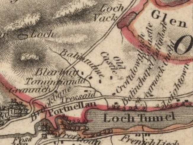
The homestead of Blairbuie was given the spelling 'Blarbuy' in early maps of Strathtummel.
Although it is now fairly remote, at that time it was not far from the hill-track between Grennich and Struan which passed alongside Loch Bhac.
On 1st December 1624, at Dunkeld, a Document of Reversion was made by Neil Stewart of Grennich, with the consent of Grizel Farquharson, his wife, to implement a contract by which he sold to Robert Calmanach for £200 Scots (£43 6s 8d stirling) the 2 merk land of Tressait and the half of Blairbuie.
One of the earliest entries in the Old Parish Records of Blair Atholl, mentions the christening of Margaret, daughter to Alexander McDonald in Blairbuie and his wife Janet Hay, on 17th August 1718. The family had, at least another, 5 children, the last being Beatrice who was born 2nd January 1736.
A second Alexander McDonald took over the lease of Blairbuie at some time between 1738 and 1744. He was married to Christian McDonald, and their first two children had been born at Grennich. Their third child, Allan, was born at Blairbuie on 25th November 1744. Alexander and Christian's last child, Donald, was born at Blairbuie on 7th December 1757. The William McDonald in Blairbuie who married Elspeth Robertson of Tressait on 14th March 1754, may have been his brother.
In 1760 William McDonald had a 15-year tack (lease), for which he paid £3 3s stirling annually, but by 1781 Blairbuie was being leased to Donald McIntyre. The 1808 rentals show that Donald McIntyre, senior and junior of Blairbuie were also renting pasture above the Pass of Killiecrankie for an annual payment of £16. Then in 1812, Donald McIntyre (presumably junior) was given a 15-year tack for Blairbuie for an annual payment of £20.
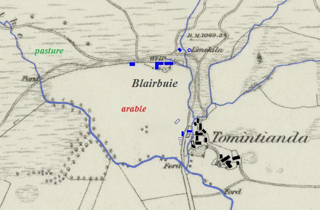
It is possible that the original Blairbuie dwellings were situated on the opposite side of the river from Tomintianda, and that the northern buildings were a later addition. Old estate maps show four buildings here, although the scant remains of only two survive today. Evidence that this was where the McIntyres were living comes from a letter of complaint sent to the Duke of Atholl's lawyer in London.
From D. Stewart, 88th Regiment, Edinburgh Castle, to Alex. Fraser Esq., London, 1st June 1818
When I was on leave of absence last October, my father told me he had mentioned to you, last time you was at Blair Atholl, how disagreeably
he and his sons were placed in the farm of Tressaid in consequence of one Alex. MacIntire, son of Donald MacIntire, Blairbuie, who in defiance
of every principle of justice, equity and without any right or authority whatever, built a house across the road which leads from the farm
of Tressaid to the common hill above, having scarcely room for a single horse and cart to pass. A lime rock on one side, the end of the
house on the other, renders it almost impossible for cattle to pass, particularly in the winter season when the rock and narrow pass is covered
with ice, which has been for many years the cause of serious losses to my father and his sons in Tressaid, who have bourne it with an uncommon
degree of patience. This man (McIntyre) makes it his chief study to annoy every man and beast belonging to the farm of Tressaid, when passing
by his doors, and from what cause I know not, unless he was born to do mischief.
In one end of the house which is built on the original road, where there was never a house before, he has constructed a forge whence he
manufactures stills and sells them, at his own prices for he has no rival, to his unfortunate countrymen who no sooner begin to distill than
they are seized and carried off, which has been the ruin on many, and partly the cause of their not being able to pay their rents.
I had a letter from my father a few days ago wherein he says that MacIntire met one of his sons between Port (Port-an-eilean) and Tressaid
and without any provocation attacked and beat him in such a brutal manner that he is now confined to bed. I am sure that it is not the wish of
His Grace, the Duke of Atholl, that his good tenants who have always been true and faithful to him, should be trampled and abused by a man who
does not acknowledge him as his superior.
It is well known to you how much I have interested myself, since the death of my poor brother, to make my old parents comfortable and to see the
rent of Tressaid regularly paid. I am now very sorry to say that from the long abuse they have received and continue to receive from MacIntire,
that I can hardly prevail on them to continue in the place unless something is done to remove their grievance.
May I beg of you, in your usual goodness, to move His Grace, the Duke of Atholl, to have this man removed who has been so long the disturber of
peace and happiness in that neighbourhood. If this cannot be effected I hope you will obtain an order from His Grace, to have that part of the
house which stands on the original road, taken down and removed, so as to leave free egress and regress to the tenants of Tressaid.
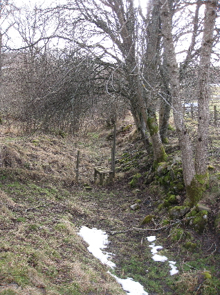
Even now the track up from Tressait becomes very narrow as it reaches the Blairbuie fields. A stone dyke has been built on the left side to keep passing animals out of the fields, whilst a fast flowing river runs down the right-hand side of the track. There are the remains of a small building on the left-hand side which is built into the stone dyke on one side and straight into rock on the other side. This may be all that remains of the 'lime rock' mentioned in the letter. A large outcrop of limestone would have been too tempting a target, and probably finished up in the lime-kiln behind Blairbuie. On the opposite side of the track there are the remains of a footing for a building which has been built at right-angles to the track, and this may have been the building which caused all of the trouble.
The letter seems to have had some effect as Alexander McIntyre departed and his uncle took over the management of the farm, although it was still officially leased to Alexander's father, Donald McIntyre. In 1822, Donald McIntyre was described by the Atholl Estate Factor thus:
As respectable a tenant as is usual in that country. He rents a farm from Col. McDonald of Glengarry at £200, while his brother John
has managed Blairbuie for three years past. There is 113/4 acres of arable, 5 acres of pasture and 60 acres of hill
pasture. He rears cows to sell at 2 years, but none this year. He grows oats, barley, turnips, potatoes and grass, but the
1/4 acre of lint was lost.
John McIntyre married Girsel (Grace) Stewart from Grennich (28th April 1822), and the family farmed the 15 acres of Blairbuie until the 1850s. For more information about this family see their memorial stone in Old Blair churchyard.
There were two other families living at Blairbuie in 1841: those of 50 year-old Alexander Stewart who worked as a mason, and another Alexander Stewart, aged 75, a wright who made spinning wheels. For more information about this latter family see their memorial stone in Old Blair churchyard.
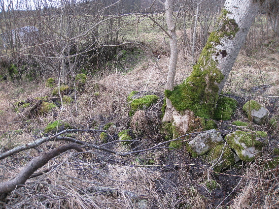
One of these families probably lived in the dwelling a hundred yards to the west of the building which exist today. The large quantity of stone, as well as the remains of a gable end indicate that this was quite a substantial house.
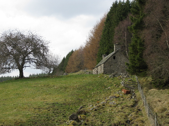
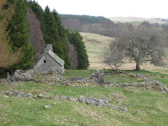
By the time of the 1861 census the McIntyre family had left and Blairbuie was being farmed by Robert Dow and Catherine Stewart (Catherine was the daughter of John Stewart the mason in Blairbuie). They must have been living in the house at the north end of Blairbuie as the 1st edition of the Ordnance Survey 6-inch map (Perthshire 1867, sheet 30), shows that in 1867 only the two dwellings at the north end were in habitation, yet there were still two families living at Blairbuie in 1871.
The Atholl Estate records for 13th September 1878 show that James Stewart the mason was paid £18 for building a house at Blairbuie, and paid £4 for repairing the byre. Although neither of these buildings are currently being lived in, the easterly one is still roofed and water-tight, whereas all the other buildings are in ruins. In addition, the moorland beyond the head-dyke wall is now a mature conifer plantation.
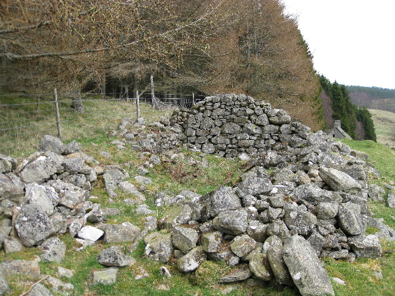
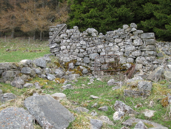
The 'L' shaped building seems to have been the second house which had the byre attached at one end. The remains of both gable ends are still standing as well as some of the walls. There are also the remains of two enclosures
The south-facing gable end has the remains of a mortar flushing on the left-hand side, which still has nails embedded in it. This seems to suggest that the roof of this outhouse was lower than the attached dwelling, and that the roof of the outhouse had a wooden frame, even if it was thatched.
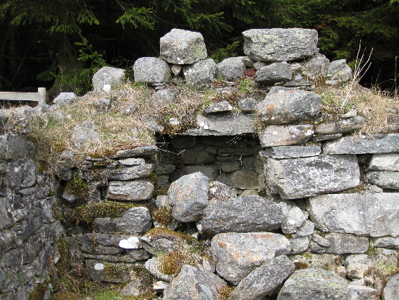
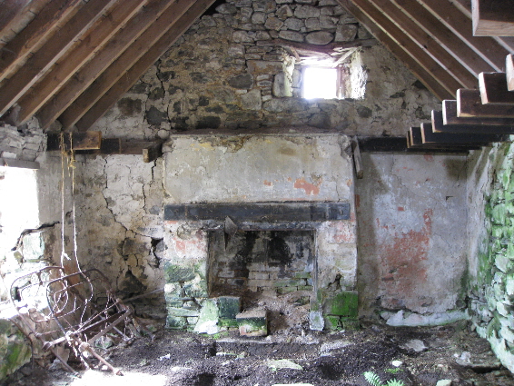
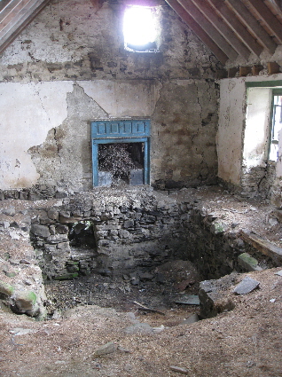
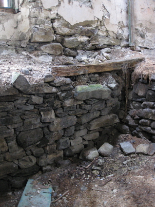
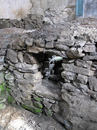
The gable end of the house itself is even more interesting as there are two deep cavities built into it, with one still retaining its lintel. It is known that the McIntyres were one of several families making whisky using an illicit still, and Janet Dow left the following recollection of an unidentified house in Strathtummel:
There were also hidden stills in the district, and on a farm we latterly stayed in, there was the remains of a huge
barrel sunk underneath the floor in an outhouse. In the kitchen, which had a stone floor, if one lifted the flags
one could descend into a room like a cellar. It had a fireplace and the smoke came out of the kitchen chimney, so
that no one detected anything. Outside, one can still see where they could roll any caskets, up or down by chute to
this cellar. Also, in the outhouse there still is, from when the building was built, a cavity left in the gable end,
to allow them to hide a casket of whisky.
The roofed house is still water-tight, but in poor condition with structural cracks in the east gable, and sawn-through roof trusses. The original fireplaces are still intact and there is plaster on some of the walls.
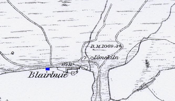
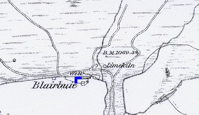
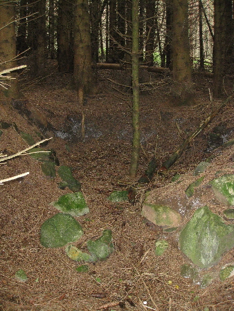
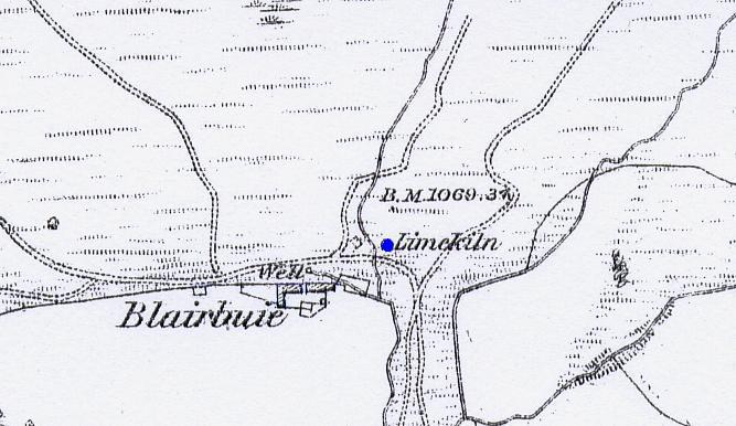
The First Edition of O.S. map for Perthshire (1867), shows an outhouse, a well, and a limekiln on the moorland behind Blairbuie. The remains of the outhouse were found within the plantation, but heavily overgrown by vegetation. No trace of the well could be found, but there was a natural spring.
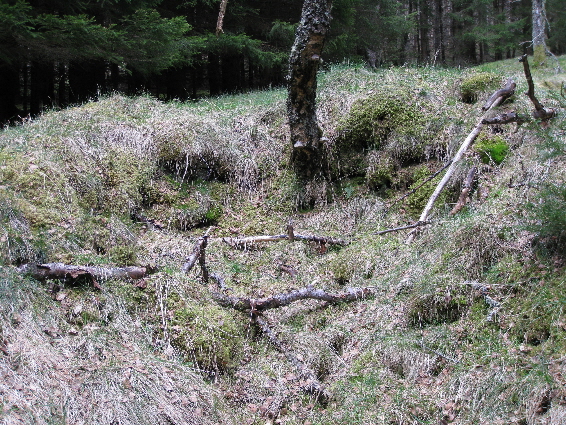

The site of the small limekiln was also found, but it is no more than a stone-lined depression which is gradually filling in with forest debris.
-
| Details of Borenich Homesteads | Stewart Births at Blairbuie | Blair Atholl Marriages | Return to Home Page |
|---|