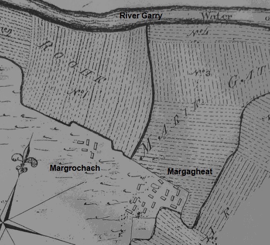
The Allt Bhaic runs through the middle of the Haugh of Invervack, dividing it into Easter Invervack and Wester Invervack. There were six settlements making up Wester Invervack: Margrochach; Margagheat; Margdou; Dondamharg; Miltown of Invervack; and Balindalloch.
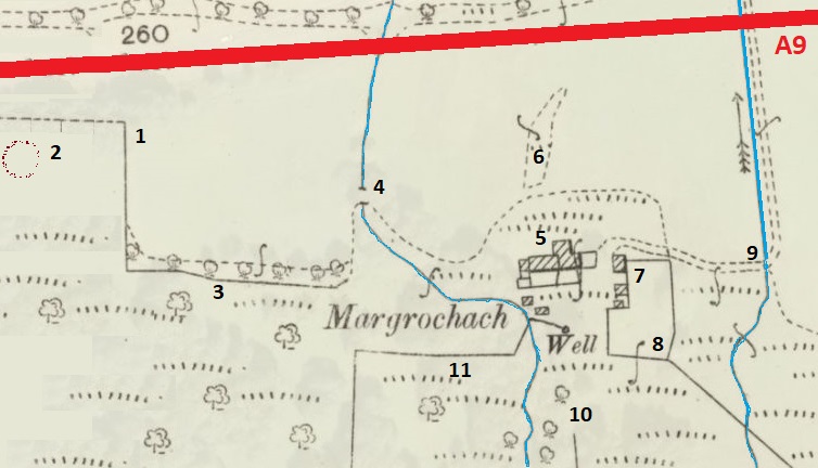
Margrochach was the most westerly and John Leslie's map of 1758, produced for the Commission of Forfeited Estates, shows five buildings. Two are orientated east-west, suggesting that they were the houses of the two tenant farmers - James McGlashan and Alexander Stewart. The other three are orientated north-south, suggesting that they were agricultural buildings, although one must have been the house of the cottar, David Stewart.
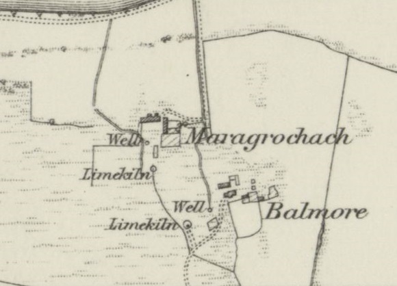
The OS six inch map of Invervack, 1840-1880, shows Margrochach as a very small settlement with a track coming up to it from the cart-track along the south side of the river Garry. The 1841 census shows that the farmhouse was occupied by two families and the OS map shows that it had two (wooden?) porches on the north side. In addition there was a large farm building just to the east which, from its north-south orientation, may have been a winnowing barn and general store. Alongside this building there was a kale-yard and a small enclosure with three trees. Slightly further to the south there was the ruin (footing?) of a disused building, together with the farm's well and a lime-kiln.
Early maps show that the land between the farm and the river was in cultivation, whereas the ground behind the farm was rough pasture.
By 1851 Invervack farm had taken over the agricultual land (65 acres) from the smaller surrounding settlements, and most families had left or given up farming. Although some of the remaining residents were described as retired farmers, the rest were carpenters, shoemakers, weavers and agricultual labourers.
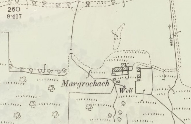
When the Invervack area was re-surveyed around 1880 the map shows that the farmhouse had been re-built with a single extension on the south side.
Scotland's 'trove.scot' website (Historic Environment Scotland) contains 3 digital images for Invervack. These originate from photograph album 7 of a Camera Club, dated around 1920.
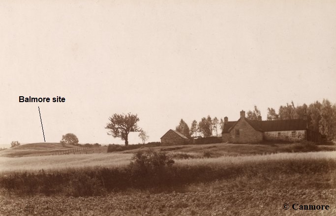
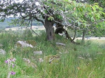
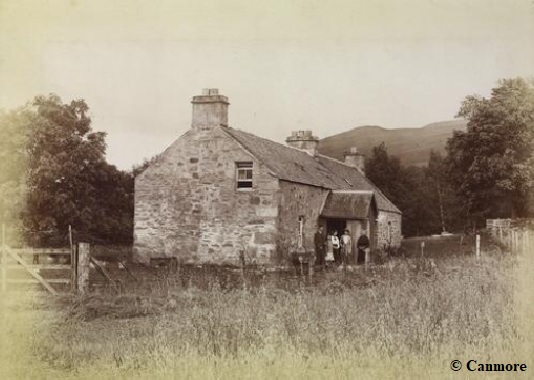
This image show Margrochach farmhouse from the north with the raised site of Balmore (Margagheat) behind it, to the left. The large tree was beside a walled enclosure made from rocks gathered during field clearance. The enclosure joined an open-sided barn with a north-south orientation and a courtyard between it and the main building. In the foreground there is a field growing a cereal crop.
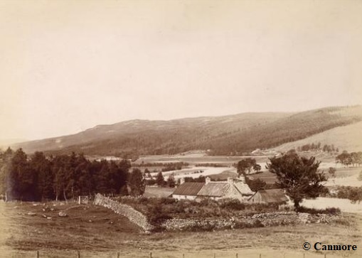
This image show Margrochach farmhouse views from the raised site of Balmore (Margagheat), south of it. The main part of the farmhouse with its northernly extension appear to have slate roofs, whereas the western end of the same building and the open-sided barn have roofs of corrugated iron. At the western end there appears to be a small wooden outhouse, possibly for storing fuel for the fires. Four chimneys can be seen: one at the east end; two towards the middle; and a fourth chimney at the west end of the corrugated roof, suggesting that there had been a change of use, from house to outhouse. The walled enclosure no longer seems to be in use, with tumbled down walls and unkept vegetation inside. The area in the foreground appears to be rough grazing.
Anyone visiting Margrochach today, seeking ruins, is quite likely to come away highly disappointed. The majority of the homestead no longer exists, but there are a few features which still can be indentified. Since the 1880 map was produced, the A9 road between Perth and Inverness has been moved from the north side of the river Garry to the south side, and now runs through the Haugh of Invervack. Future plans to convert the road to a dual carriageway may well affect the site even further.
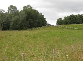
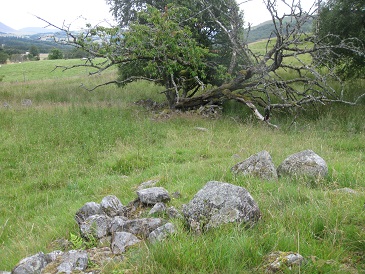
When driving along the current A9, the only obvious man-made structure is a length of drystone wall on the hillside above a layby (1).
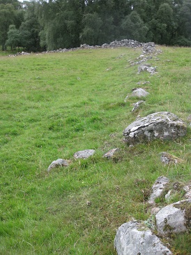
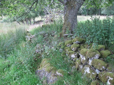
The head-dyke was built on a grassy slope and constructed from field clearance as a drystone wall (i.e. without lime mortar). The rocks may have been held together by a mortar of mud, river grit and chopped up straw, but any evidence has long since gone. Walls like this were often capped with upturned turves for further protection.
Originally this wall, eventually, would have continued down to the river Garry. Its purpose was to prevented livestock, normally grazing on the higher moorland, from damaging the fields of barley and oats below the head-dyke. The 1756 Forfeited Estates Census shows that both flax and potatoes had been grown at Margrochach.
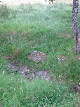
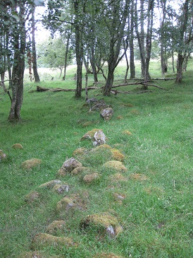
The ground beyond the head-dyke, although rough, is fairly flat. At the highest point there is a large circular depression in the grass (2). Some medium sized rocks show through the grass around the circumference, but not in the centre of the depression. One possibility is that this has been a round-house, dating back to the iron-age. Invervack was an important site, known to date back for centuries, so the existance of a previous iron-age settlement might be expected. The paucity of remaining stone makes a definite judgement difficult but, if it was a round-house, then the rocks would have been pillaged to build houses and farms at a later date. A proper excavation would resolve the question.
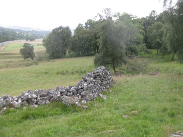
Where the head-dyke turns sharply east towards the farmhouse, the wall is in much better condition than higher up, and approximately 1.5m in height. There are a good number of trees along the line of the wall, including silver birch, ash and rowan (3). The wall peters out before reaching the stream. The whole of this area would have been in cultivation at one time.
The 1880 O.S. map gives the impression that there was a small bridge crossing the steam that runs down on the west side of the farm. In reality, a number of flat slabs have been positioned in the bed of the stream to make a narrow ford (4). The ford was positioned down-stream of the 'farm well', so that the drinking water was not sullied with mud. Although the stream is now just a trickle, there must have been a great flow in the past as the east bank above the ford was reinforced with stone to prevent erosion.
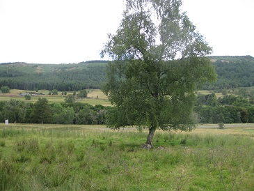
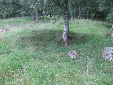
The position where Margrochach farmhouse once existed can be identified by aerial photography, and is marked by an isolated tree growing on the flat site. The demolition took place around the 1950s and obliterated the farmhouse complex, most of the adjacent walled enclosure with its outhouses, as well as the approach road.
The stone rubble from the demolition was bulldozed down the slope to the north and flattened. None of the stone shows any sign of having been dressed, nor any traces of lime mortar, so the building was quite basic in construction. Presumably the chimneys also were made from the same material as there is no trace of any bricks amongst the rubble. It is assumed that the roof tiles, corrugated metal and roof timbers were salvaged prior to demolition, as there are no traces remaining at the site. It is possible that some stone flooring still exists under the grass at the original site but, as there is no trace of any wall foundations, all may have been removed.
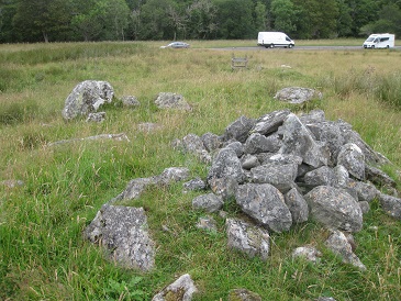
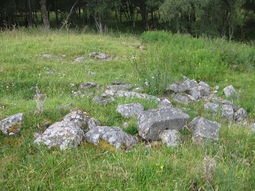
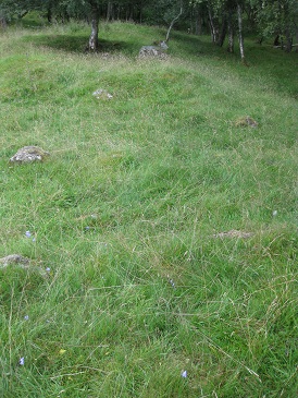
The 1880 O.S. map shows that the mounds (6) slightly to the north of the Margrochach farmhouse site are a natural outcrop forming an island between the cultivated fields. There are piles of large rocks on top of the mounds. The rocks may have come from the demolition process but, more likely, they are piles of field clearance from much earlier times.
Although there was a cart-track along the south side of the river Garry, linking the farmsteads of Invervack and Pitaldonich, the road between Perth and Inverness was on the north side of the river. There were two ferries which were used when the fords were impassable: one at Pitaldonich (Boat of Pitaldonich); and the other at Apersuaine (the ford of the Sunart bard). Both used flat rafts which could carry people, carts and livestock, as required. Each raft was connected to a metal chain which was secured on either side of the river, allowing the raft to be pulled across. The cart-track up to Margrochach is shown on the 1880 O.S. map but it has disappear with the lack of use. Only the entrance site remains (9), marked by a much more modern metal farm gate.
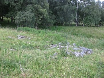
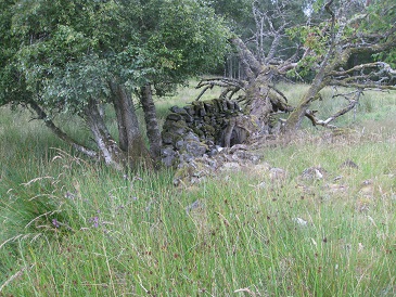
The two photographs of 'Invervack' taken around 1920, previously shown, give a good impression of the walled enclosure and adjacent outbuilding at that time. However, neither now exist to any great extent. All that remains is the east wall of the enclosure and part of the south wall. The photographs also show a large ash tree and some small trees further back which have survived.
The smaller trees in the 'Invervack' photographs are cherry trees dating from when the enclosure produced home-grown fruit and vegetables. Alas, the trees are no longer fruiting.
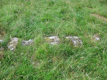
The south-east corner (8) of the walled enclosure is still intact. It shows that the thin coping stones had been arranged vertically to make a decorative feature, rather than just being functional.
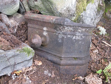
Abandoned in the corner is an old cast-iron object, half buried by rocks and earth. It appears to have been the hearth of a fireplace.
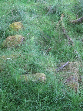
It is still possible to make out the alignment of the south wall of the enclosure from the remaining rocks in the ground. Three of the largest rocks have been dislodged from the wall and have rolled a little to the south. The wall turns northwards at the trees, one of which has recently fallen.
The 1840 O.S. map shows the presence of a limekiln (10) just to the south of the farmhouse, with a wall running south from it. This limekiln is merely a circular depression in the slope of the ground with a few large rocks around the perimeter. Its simple form, with no stone basin to retain the heat, is typical of the early limekilns built in the 1750s and 1760s. Before the Struan Estate came under the management of the Forfeited Estates Commissioners there was no lime production using limekilns in this area.
When the rentals of Margrochach and Maragagheat (Balmore) combined after 1803, this limekiln may have been required no longer. A more efficient limekiln had been built close by at Margagheat and the old one fell into disuse.
An outhouse close to the south-west corner of the walled enclosure, and orientated north-south is shown in the 1840 O.S. map. The 1880 O.S. map does not show it, and all that remains today are some stone footings of what might have been a cruck-framed building.
The O.S. maps show a well to the north of the lime kiln and outhouse, with a wall generally leading westwards from it. The term 'well' can cover a variety of structures from natural springs to a dug-out shaft and bucket. This 'well' is not much more than a place where 'clear water' cound be collected. Although the 'well' is close to a stream, the stream water might have been quite dirty and rather unpalatable. Likewise, water could have been collected from the river Garry, but carrying buckets of river water uphill is strenuous.
A number of flat stones have been laid together to form a dry platform beside the 'well'. Although the 'well' is now more of a large depression, having filled with sediment. originally it would have been a large, deep hole filling with run-off water while any sediment settled to the bottom. It is possible that there was a wooden conduit filling the 'well' with water from the adjacent stream. A bucket lowered into the hole would have collected clear, clean water for domestic purposes.
There is an upper dyke-head wall (11) running, generally, westwards before turning sharply south. Like most of the dyke-head walls, it is in a poor state but has not been deliberately pulled down.
.....................................................................................
The location of this building is yet to be elucidated, but it does not match Margrochach, Balmore (Margagheat) or Markdou.
-
| Return to Home Page |
|---|