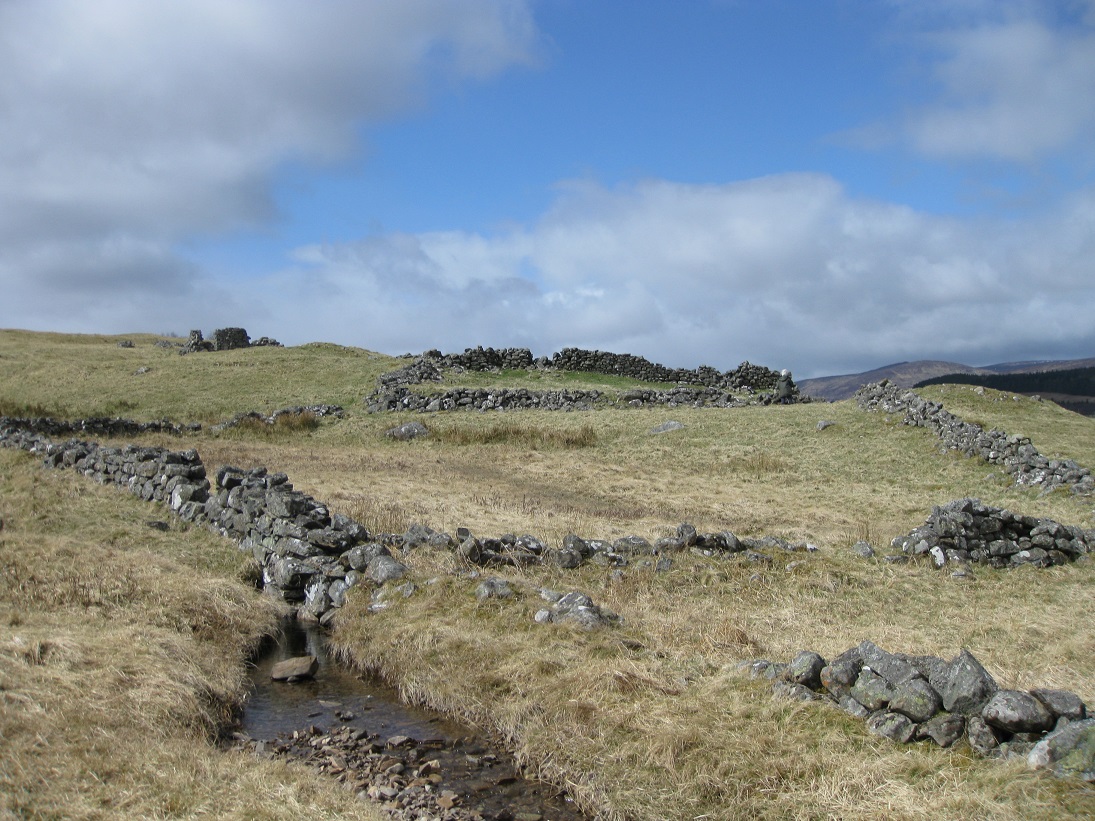
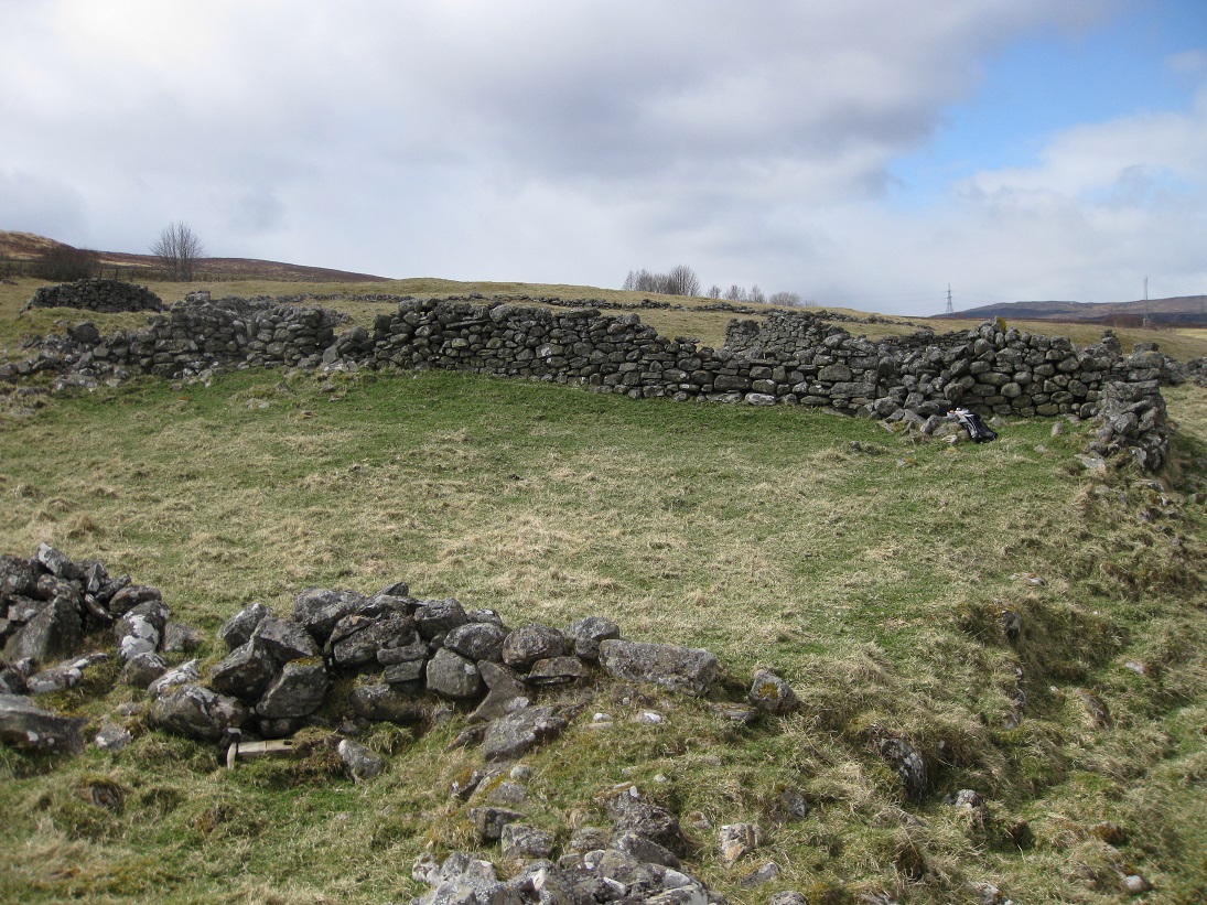
The 1st edition of the Ordnance Survey map (1867) shows Tomicaldonich as being in ruins although it was in habitation as late as 1851. The map shows two buildings, two enclosures and two head walls running east and west. The circular sheep fank seems to have been built at a later date, using stone from the ruins.
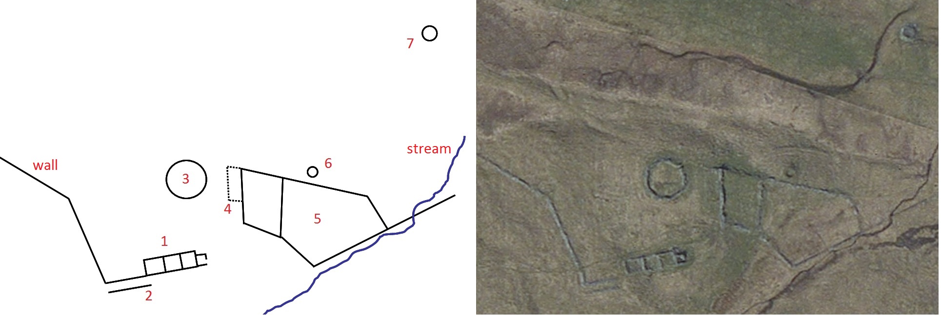
The head dyke running west from Tomicaldonich continues as far as the next settlement of Easter Dalriach (East Dail-an-fhraoich). The current RCAHMS map shows the head dyke connected to a rectangular building at Tomicaldonich, but this seems to be in error. The 1867 O.S. map does not have a building at this location, and the site study shows just a length of stone dyke (2) running parallel to the head dyke. There is no evidence of gable walls and the two walls are less than 5 metres apart; the typical distance for a building. The purpose of this structure is unclear, but it may have been used for inspecting sheep.
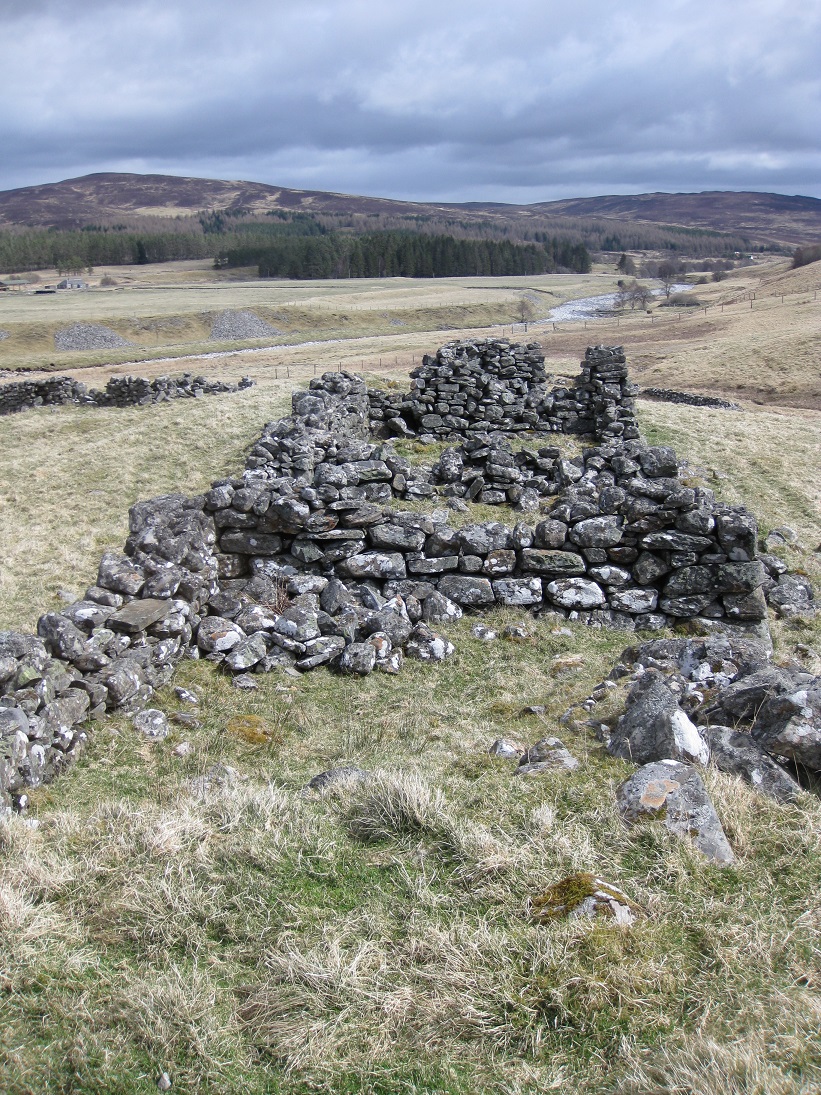
The Blair Atholl Old Parish Register of births suggest that Tomicaldonich could only support one family and building (1) seems to have been their
dwelling house. As is the norm, the house is orientated east-west with the doors facing southwards, towards the sun. The walls are of un-mortared
dry-stone construction using, for the most part, regular blocks of striated rock which may have come from the bedrock of the nearby River Garry.
It is probable that the original stone walls and gables were quite high, but the exact height is difficult to assess as the ruins have been pillaged
at a later date, to build the circular sheep fank. The building was probably constructed in the late 1700s using the base of a previous house.
The building consists of three equally sized rooms, with stone dividing walls, and a smaller compartment at the eastern end. It is possible that
the original house consisted of just the middle two rooms. There are hardly any stones at the western end where a substantial gable might be
expected, and the arrangement of stones in the dividing wall have more of the appearance of a gable end. If this is the case, then the most
westerly compartment was probably an open-ended byre.


There appear to have been two rooms in the house but there is no sign of a fireplace or 'hanging lum' and the roof must have been covered with
thatch as there are no traces of slates amongst the ruins.
The end compartment is a bit of an oddity. Firstly, the compartment is quite small, not much more than two by two metres with the door facing east
and abdth = "500" alt="The old store at Tomicaldonich " />
The second building (4) shown on the Ordnance Survey map (1867) was orientated north-south and attached to the upper enclosure wall. The orientation and small dimensions are typical of a store or animal byre. Today, only a few grass covered stones provide the outline of the original footings. Doubtless, some stones are now part of the sheep fank, but the original building may have been mostly a construction of turf divots. There is evidence for the building to have been in two parts.
The two enclosures join each other and are continuous with the eastern head dyke which runs alongside a small stream. They may have been used as vegetable gardens or as animal enclosures. General Roy's map of the Highlands shows that the area between the homestead and the river was under dth = "500" alt="The old store at Tomicaldonich " />
The second building (4) shown on the Ordnance Survey map (1867) was orientated north-south and attached to the upper enclosure wall. The orientation and small dimensions are typical of a store or animal byre. Today, only a few grass covered stones provide the outline of the original footings. Doubtless, some stones are now part of the sheep fank, but the original building may have been mostly a construction of turf divots. There is evidence for the building to have been in two parts.
The two enclosures join each other and are continuous with the eastern head dyke which runs alongside a small stream. They may have been used as
vegetable gardens or as animal enclosures. General Roy's map of the Highlands shows that the area between the homestead and the river was under
cultivation, so most of the animals must have roamed free on the moorland above the head dykes. The Atholl Estate limited the number of animals
that each tenant could keep on the open moorland by a system called 'souming'. In 1771 the tenant of Tomicaldonich was allowed to keep: 12 cows
and followers (calves); 4 horses, 2 mares and followers and 90 sheep and followers.
In 1796 a petition to the Duke of Atholl from Alexander McGlashan stated that he had made numerous improvements in the nine years that his family
had been tenants, including rebuilding houses and erecting stone dykes. Even so, three years later, a new stone dyke had to be built where the
Dalnacardoch land started, to prevent the impounding of livestock which wandered into the fields of Patrick Robertson, vintner at the inn
of Dalnacardoch.

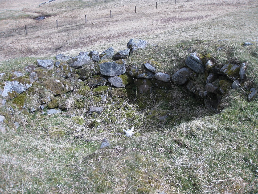
The land slopes down from the upper enclosure to the glacial moraine terraces of the river Garry, and just to the north of the upper enclosure a corn-drying kiln has been built into this slope. Although the outside of the kiln bowl is covered with grass, the stonework inside is remarkably intact. The bottom of the bowl has filled with soil so that the flue from the hearth is not visible.
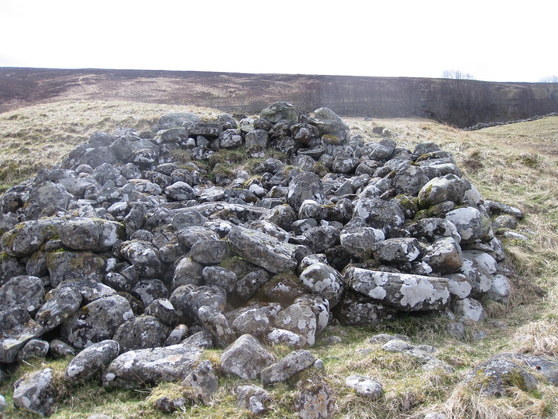
A small distance further down the slope, to the north-east, there is a pile of stones. At first glance it appears to be field clearance from the arable land below, but closer inspection shows that the stones have been arranged deliberately to form a near circular structure built into the slope. An aerial view shows the shape of a lime kiln which has collapsed down the slope. Alexander McGlashan's petition of 1796 mentions that he was using lime on the fields to increase their fertility. The limestone was being brought from Auchleeks in Glen Errochty where the seam passes behind Trinafour.
The Owners and Tenants of Tomicaldonich
Alexander Stewart 6th of Tulloch sold Tulloch hill, opposite Blair Castle, to Duke John Murray so that the Duke could landscape the policies across the
river Garry, making it appear to be part of the parkland around the castle. In return, a contract of wadsett was drawn up at Blair Castle on 4th
September 1723, between the Duke and Alexander Stewart, whereby for the sum of £3,063 5s 4d Scots Alexander Stewart held the lands of Dalinturuaine
and the pendicle of Tomicaldonich. Alexander Stewart annually paid £5 3s 8d Scots superplus (the difference between the annual rent and the annual
interest on the wadsett loan). The wadsett could be redeemed by either party at Martinmass, giving 40 days notice, and the redemption would take
place at the Kirk of Blair (St Bride's).
The wadsett must have been redeemed by 1738 as, in January of that year, the Duke granted feu rights for Dalinturuaine and Tomicaldonich to Donald
McDonell of Sandwick, a cousin of Glengarry, who adopted the title of 'Lochgarry'. To pay the Duke of Atholl, McDonell of Lochgarry granted a wadsett
for Tomicaldonich to Duncan Robertson in exchange for a loan of 2,000 merks. Unfortunately for Duncan Robertson, Lochgarry was involved in the '45
Jacobite uprising and his estate was forfeit to the Crown. As a consequence, when Duncan tried to redeem his wadsett he found that he was just one of
many creditors, and that the Commissioners for the Forfeited Estates expected back payment for past rents or his removal. To his credit Ensign
James Small, the Forfeited Estates Factor, took pity on the family and wrote on his behalf to the Commissioners explaining the circumstances.
In 1787 Tomicaldonich was being tenanted by John McGlashan and his son Alexander, and most of the present ruins probably date from this period. By
1820 Tomicaldonich had been combined with Dalnamine and Dalinturuaine and Lieutenant Duncan Robertson had a 15 year lease for them all. The last
record of habitation appears in the 1851 census where Alexander Robertson is described as a farmer of 14 acres.
| Blair Atholl Marriages | Return to Home Page |
|---|